Chapter 1 Introduction
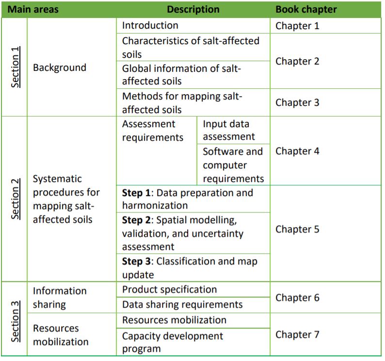
Salt-affected soils are soils with high amounts of soluble salts and/or sodium ions. The salts hold water in the soil at high osmotic potential, which limit easy exchange of water and nutrients with the plant roots. Consequently, they retard growth and development of many plants. Their global distribution was first estimated in the late 1970s at about 1 billion hectares (Szabolcs, 1979; Abrol et al., 1988). Since then, there has been inconsistent updates of their distribution. Recent literature at the global scale mostly use data that was collected in the late 1970s and portray global distribution of affected areas at about 1 billion hectares (FAO/IIASA/ISRIC/ISS-CAS/JRC, 2008; Wicke et al., 2011; Ivushkin et al., 2019). A new update is necessary to improve knowledge of the status and actual distribution of salt-affected soils. Salt-affected soils have significant impacts on the environment, water, and agriculture. They negatively influence agriculture productivity and quality of soil and surface water but also have significant economic potential if they are properly managed (Wicke et al., 2011). An improved knowledge of their distribution, characteristics, and trend is necessary for sustainable management and economic exploitation. The current lack of consistent information update of salt-affected soils is hampering policy developments to support management and alternative uses of these soils. In 2018, the Global Soil Partnership (GSP) Plenary Assembly deliberated on the global information gap for salt-affected soils and requested for global mobilization to update the information (GSP-FAO, 2018). Following the request, GSP conducted a survey among member countries as a first step to gain understanding of the status of salt problems and identify areas to focus on when mobilizing for information update. The survey revealed that more than 70% of the countries have varied aspects of salt problems and data for mapping salt-affected soils (Figure 1.1). However, most of the datasets are old and need updating.
Figure 1.1: Survey results on country-level data availability for mapping salt-affected soils
In this manual, the GSP global mobilization approach is used to develop information update of salt-affected soils. The approach is a country-driven process where countries (partners) develop and contribute global soil information but retain the copyright of the contributed soil data (Figure 1.2). The process is globally coordinated by GSP in collaboration with International Network of Soil Information Institutions (INSII) and focal persons (FP) in each country. The whole process is supported with technical documents developed by the technical bodies within GSP such as Pillar four Working Group (P4WG) and Intergovernmental Technical Panel on Soils (ITPS) (FAO and ITPS, 2018). This manual is part of the technical documents for supporting the global mapping of salt-affected soils (Figure 1.2). One of the challenges in updating global information using the approach in Figure 1.2, is the potential uncertainties due to differences in datasets and approaches by countries. There are many methods and indicators in the literature which countries can use in mapping and classifying salt-affected soils. Unless the country data and methods are harmonized, the contributions can be disorganized and result into uncertain global map of salt-affected soils. The focus of the present manual is to provide guidelines for harmonizing input data and approaches for mapping salt-affected soils. The book puts emphasis on popularly used soil indicators for diagnosing salt problems in the soils (Figure 1.1) and a harmonization protocol for all contributing countries.
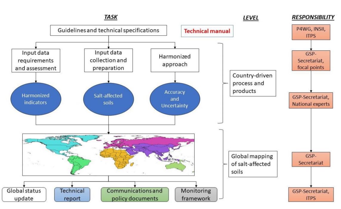
Figure 1.2: Country-driven framework for global mapping of salt-affected soils
1.1 Presentation
This book is organized into three sections covering seven chapters. The sections are sequentially arranged but independently designed to benefit focused readership who may want to go straight to any section. Section 1 gives the background information, Section 2 covers the methodological procedures for developing multiscale spatial maps of salt-affected soils, and section3 outlines the steps for information sharing and resources mobilization (Table 1.1). Section 1 has three chapters that gives brief literature review on the characteristics of salt-affected soils and methods for their mapping. The section is intended to provide readers with basic concepts linking the characteristics of salt-affected soils with data requirements for mapping and classifying these soils. It also discusses the mapping methods and existing information on the global distribution of salt-affected soils. Section 2 describes the procedural steps for developing maps of salt-affected soils (Table 1.1). Section 3 outlines the requirements and procedures for information sharing and resource mobilization for developing or monitoring salt-affected soils.
Table 1.1: Book presentation